EAGLE CREEK TRAIL

JULY 2014

METLAKO FALLS

LOWER PUNCH BOWL FALLS
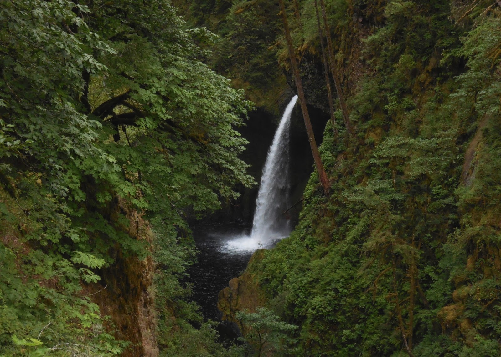
LOOWIT FALLS

EAGLE CREEK FROM HIGH BRIDGE

SKOONICHUCK FALLS

NEAR THE BEGINNING OF THE EAGLE CREEK TRAIL

TUNNEL FALLS

TUNNEL LEADING BEHIND TUNNEL FALLS

TUNNEL FALLS

TWISTER FALLS

EAGLE CREEK ABOVE TWISTER FALLS

WY'EAST FALLS

PUNCHBOWL FALLS

Eagle Creek, in my opinion, is the premier hiking trail in the Columbia River Gorge. The 13-mile roundtrip trail takes you through a thick, green forest along a creek with multiple picturesque waterfalls. However, it may not be quite as pretty now as it was when I hiked it. A large wildfire struck the area in the summer of 2017, and the trail is expected to be closed until spring or summer of 2018. Hopefully the large amount of rainfall this area receives will help it to recover quickly.

Eagle Creek is a very popular trail, so expect big crowds if you go on a weekend in the spring, summer or fall. As I had recently started a new job in the summer of 2014, I was low on vacation days and ended up visiting on the Fourth of July weekend. Since I was visiting from Boise, I used my one-hour Mountain Standard Time advantage to wake up early and beat everyone to the trailhead. I started hiking just as it became light and had the entire area to myself for the first five miles or so until some back-packers started waking up along the sides of the trail. However, on my way back down I ran into the back of a long train of people about two or three miles from the trailhead which I was unable to pass. 

The first waterfall you will come to on the hike is Metlako Falls via a short side trail. This may have been my favorite one. Unfortunately, I read that the trail to Metlako Falls was closed in January of 2017 due to the trail eroding away. Hopefully an alternate route can be made to the falls in the future. Next you will pass a side trail leading to Lower Punch Bowl Falls, and then some side trails leading to Punch Bowl Falls. After Punch Bowl Falls you will pass Loowit Falls and come to High Bridge, which gives you a great view of a narrows section of Eagle Creek from high above. 

The next falls you will bass will be Skoonichuck Falls and Wy'East Falls. Wy'east Falls is hidden a little ways off the main trail so be alert. I missed it on my way up, but was glad to find it on my way back down. After about six miles of hiking, you will come to the grand finale, Tunnel Falls. It is a very large falls with a tunnel carved into the mountain letting you walk right behind it. I decided to walk a half-mile past Tunnel Falls to view Twister Falls before returning to the trailhead.  

ONEONTA GORGE

JULY 2016

ONEONTA FALLS


ONEONTA FALLS

ONEONTA FALLS

ONEONTA GORGE

Oneonta Gorge is beautiful 0.6-mile roundtrip hike through a river to a beautiful moss-covered waterfall. Because the hike is located along the Historic Columbia River Highway in-between the Multnomah Falls and Horsetail Falls trailheads, it receives a lot of visitors. As the trail is not advertised from the roadway, I only discovered it while hiking the trail to Triple Falls, which passes just above the canyon, and hearing voices coming from below. 

Because I was hiking the trail in July, I decided to get to the trailhead just before dawn in order to beat the crowds. It worked, as I had the entire gorge to myself. There is a log jam you will need to work your way over near the start of the hike, and then you will wade up the river to the falls. Most of the river is fairly shallow, however there was one chest-deep section to wade through just before the falls.  

MULTNOMAH-WAHKEENA LOOP HIKE

JULY 2014 & JULY 2016

MULTNOMAH FALLS

WEISENDANGER FALLS

NEAR FAIRY FALLS

COLUMBIA RIVER

ECOLA FALLS

FAIRY FALLS

MULTNOMAH FALLS

TRAIL ABOVE WAHKEENA FALLS

WAHKEENA FALLS

WAHKEENA FALLS

The Multnomah-Wahkeena Loop, is one of my favorite hikes in the Columbia River Gorge, as you pass by eight waterfalls in just under five miles of walking. I've hiked this trail twice, once beginning at Wahkeena Falls, and once beginning at Multnomah Falls. Multnomah Falls is the most visited spot in the Columbia River Gorge, so expect large crowds near the beginning of the hike.  

From the Multnomah Falls trailhead, it is a very steep climb up some paved switchbacks to the top of the waterfall. A little past the Multnomah Falls Overlook, you will reach Weisendanger Falls, which has a side trail taking you to its base. Just past Weisendanger Falls is Ecola Falls, which also has a side trail leading to it, though it is pretty steep. 

After Ecola Falls, you will leave the river and head through a heavily-wooded section of forest. This was a really peaceful stretch as there were not too many people hiking it. Eventually you will reach a fork giving you the option to hike to Wahkeena Spring, or taking a short-cut to Fairy Falls. Both sections are really nice. The spring is really pleasant, but is okay skipping if you are in a hurry. Next you will pass by Fairy Falls, and some more nice cascades along the trail as you switchback down the hillside to Wahkeena Falls.  

ELOWAH FALLS

FEBRUARY 2015 & MARCH 2016

ELOWAH FALLS

ELOWAH FALLS

ELOWAH FALLS

ELOWAH FALLS

UPPER MCCORD CREEK FALLS

Elowah Fall is a very beautiful 1.4-mile roundtrip hike located just off the I-84 freeway. A very short, relatively easy hike takes you to one of the most impressive falls in the Columbia River Gorge. 

My first time hiking to Elowah Falls I added on the 2.2-mile roundtrip hike to McCord Creek Falls located above Elowah Falls. While not nearly as cool as Elowah Falls, it is worth visiting if you have time.  

PANTHER CREEK FALLS

FEBRUARY 2015

PANTHER CREEK FALLS

PANTHER CREEK FALLS

PANTHER CREEK FALLS

PANTHER CREEK FALLS

PANTHER CREEK FALLS

ABOVE PANTHER CREEK FALLS

PANTHER CREEK FALLS FROM ABOVE

PANTHER CREEK FALLS FROM ABOVE

PANTHER CREEK FALLS FROM ABOVE

The Panther Creek Falls are amazing. They are located just off the side of the road, so a very short walk is all that is required to reach them. After finding the parking area, you will cross the road and backtrack a couple hundred feet until you find a trail leading to the overlook area. There is nice boardwalk located above the falls giving you a good view of them from above. If you want to see the falls from below, a very steep, muddy decent is required.   

Bring detailed directions if you visit, as they were not easy for me to find. They are located in a thick forest north of the Columbia River Gorge in Washington, and when I visited there was no signage of any kind along the road letting you know where they were. It looks like it may be becoming more popular as I saw the parking area and trailhead have been marked on Google Maps now. I visited Panther Creek Falls early on a February morning, and did not see anyone else while I was there. The Gorge is a much more peaceful place in the winter.    

WAHCLELLA FALLS

FEBRUARY 2015

WAHCLELLA FALLS

WAHCLELLA FALLS

Wahclella Falls is a really nice, flat two-mile round-trip hike located just off of the I-84 freeway. Not too far into the hike you will take a foot bridge that passes just under Munra Falls. A little further on the trail will split. It's a loop trail, so it doesn't matter which way you go. The nicest views are on the low trail to the right, as it will take you along the river and give you great views of the surrounding canyon walls, which had water cascading off them in some points while I was there. Wahclella Falls is impressive. It is a very high-volume, two-tiered waterfall, that crashes loudly into a large pool of water. 

LATOURELL FALLS

MARCH 2016

LATOURELL FALLS


SIDE TRAIL

LATOURELL FALLS


Latourell Falls is a pleasant hike to an impressive waterfall located along the Historic Columbia River Highway on the west end of the Gorge. From the trailhead it is just a short walk down to the base of the falls. While I only hiked to the lower falls, there is also a 2.4-mile round-trip hike that will take you to Upper Latourell Falls which I will need to try sometime. 

GORTON CREEK FALLS

JULY 2016

GORTON CREEK FALLS

GORTON CREEK FALLS TRAIL

GORTON CREEK FALLS

Gorton Creek Falls is a beautiful 1.2-mile round-trip hike located just off the I-84 freeway. The trail passes through a lush forest and by Emerald Falls before ending in a rocky section you will need to scramble up to get a good view of the falls. 

DRY CREEK FALLS

FEBRUARY 2015

DRY CREEK FALLS

BELOW DRY CREEK FALLS

DRY CREEK FALLS

DRY CREEK FALLS

Dry Creek Falls is a very impressive waterfall located in a large basalt amphitheater. It is reached by a 4.4-mile round-trip hike through a peaceful forest located just outside of Cascade Locks.